Mapper and GIS
For more information about mapping tools in TRACS, visit Course 6: Mapping Tools.
1. What is GIS?
A geographic information system (GIS) is a computer system capable of capturing, storing, analyzing, and displaying geographically referenced information, that is, data identified according to location. Practitioners also define a GIS as including the procedures, operating personnel, and spatial data that go into the system (Service Manual 270 FW 8).
2. How does GIS pertain to the TRACS mapper?
TRACS includes a mapper which is a web-based GIS tool, customized to meet the needs of the Office of Conservation Investment, our partners, and the Service's Manual (270 FW 8). This policy encourages the use of GIS to enhance resource management, administrative activities, and coordination, through cost-effective creation, analysis, and exchange of spatial data. Also, GIS can help avoid duplication of effort by coordinating projects within the Service and with our partners. GIS is expected to enhance and streamline management and reporting capabilities, while improving our transparency to legislators, related industries and the public. See Question 5 "What type of geospatial data apply to TRACS?" below for more details.
3. Why does TRACS feature
geospatial information?
There are several benefits of geospatial information. It aids communication by showing where grants are occurring and the spatial relationships with other grants. It also provides the capability for automated data entry, and spatial queries for analysis and reports.
4. Is geospatial data required?
Geospatial data is only required to the extent that it is necessary to fulfill the requirements of regulations for describing the geographic location of performance data and inventory (real property and facilities) records.
For real property interests, we recommend a survey by a qualified surveyor at a data-scale of 1:100 or less, to help ensure better accounting and control of those interests (520 FW 6 and 520 FW7).
5. What type of geospatial data apply to TRACS?
The type of geospatial data that apply to TRACS are those that pertain to mapping the geographic location(s) of performance data for the strategy "Direct Habitat and Species Management", as well as Sites, Facilities, and Real Property Records. Users may have the option to select a geographic location such as the state (or more specific locations, such as counties, WMAs, etc.) or draw a polygon or point on the mapper. Also, users can upload shapefiles to further facilitate the mapping process. Note: No lines or multi-line features can be used in TRACS or loaded as shapefiles.
Locations in TRACS where geospatial data may be applied:
- Performance Module - Performance Reports: Mapping tools are available for activities with the strategy of “Direct Habitat and Species Management”. The user has the option to either “Draw a Shape” or “Pick a location”. If “Draw a Shape” is selected, the tools to “Draw Polygon”, “Upload Shapefile” or “Pick a Location Instead” display.
- Inventory Real Property Module - Real Property Records: Mapping is required for Real Property records in the Inventory Module. On the Location tab, the real property location can be defined by a polygon or shapefile.
- Inventory Facilities Module - Site Details: The mapping tools are optional on the Site Details form, with options to “Draw a Shape” or “Pick a Location”. If “Draw a Shape” is selected, the tools to “Draw Polygon”, “Upload Shapefile” or “Pick a Location Instead” display.
- Inventory Facilities Module - Facility Records: Mapping is required for Facility Records in the Inventory Module. On the Location tab, the facility location can be defined by a polygon, a point or a shapefile.
6. At what scale is geospatial data required?
The scale and accuracy level of geospatial information must sufficiently describe the geographic location enough to meet program and environmental compliance review needs. The scale and accuracy level will vary depending on the grant and inventory record type and scope.
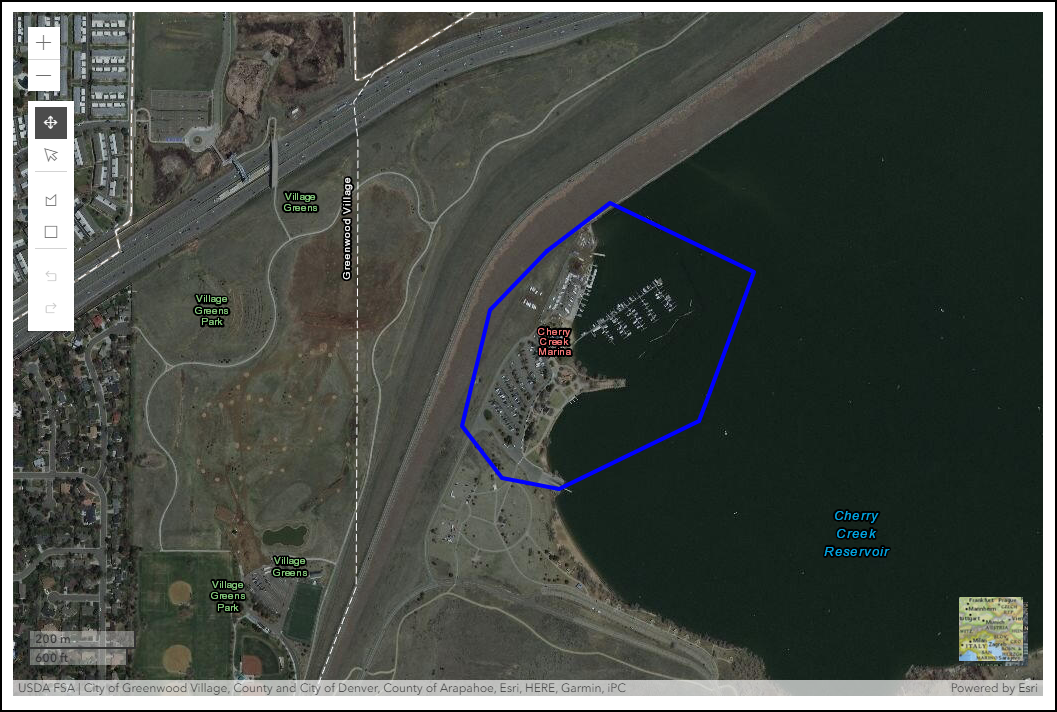
The polygon mapping tools are available when the map is zoomed in to a scale of at least 1:24,000, which is 0.4 km/0.3 mi or closer for a polygon as seen below:
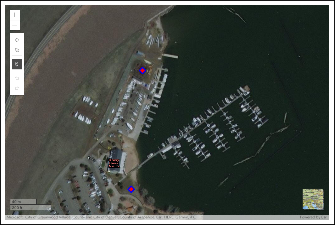
To add one or more points (available for the Facility Location) , the map must be zoomed into 0.3km/1000ft.
7. At what accuracy should TRACS features be mapped for objective(s) for performance reporting and Inventory Records (Site, Facility and Real Property Records)?
At a minimum, Facilities must be mapped within their Site boundaries. TRACS features should be mapped using the following methods, in order of preference:
a. Import an existing shapefile of the feature. (See the next page for shapefile import restrictions and question 6 for specific data-scale suggestions.)
b. Select a feature from existing TRACS data layers (e.g. state, county, Wildlife Management Area, etc.)
c. Draw features at the best resolution/scale possible.
8. Does TRACS have the capability to store geospatial information as points?
TRACS has an option to map a point for Facilities Records (i.e. features). However, to calculate feature areas and accurately represent the geographic location/boundaries, all features must be entered into TRACS as polygons. Although points do not represent areas or boundaries, GIS software can be used to convert point features to polygons using a reasonable buffer distance. For example, survey points can be represented by polygon-circles using the radius surveyed, or a stream could be represented by a polygon using the stream width.
9. How are the areas of polygons in TRACS used in performance reporting?
The polygon area is used for standardized reporting (i.e. acres by strategy or activity type). However, performance reporting is based on progress toward end-user defined objectives, which can differ from polygon acres. Note: Polygons are only used in performance reporting for the strategy of "Direct Habitat and Species Management". Performance reports with a strategy of "Real Property Acquisition" must be linked to a Real Property Record, which is mapped with a polygon or shapefile. Performance reports with a strategy of "Facilities/Areas Construction, Renovation or Acquisition" must be linked to a Facilities Record, which is is mapped with a polygon, point or shapefile.
10. Can additional reference layers to select as a location be included in TRACS in the future?
Yes. Reference layers in TRACS will be available in a future enhancement for a 'geopicker' tool for ease of selection and re-use by all users. Layers that make good candidates for TRACS include relatively static spatial data that is used with frequency to create boundaries. Examples of layers that might be included in TRACS are: Wildlife Management Areas (WMAs), Game Management Areas (GMUs), etc. This is the preferred approach for spatial data that is very detailed, large scale, or used with frequency. Reference layers made available in the 'geopicker' tool are treated as "shared shapes," meaning a single shape is associated with multiple records so long as the shape does not change. Shared shapes result in system efficiencies because geographic information is calculated once and the shape is drawn once for all records associated with the shape.
11. What is the process for submitting a new reference layer for inclusion in TRACS?
Prior to submitting a reference layer for inclusion in TRACS, you must ensure the data is in a typically recognized coordinate system (e.g. UTM, state plane, geographic, etc.). The preferred format is either WGS 84 Web Mercator or WGS84 to minimize the re-projection in the TRACS app. Only vector data may be submitted for inclusion in the 'geopicker' tool. Compress the required files of the shapefile (*.shp, *.shx, *.dbf, *.prj) into a single *.zip file. The *.zip shapefile may then be submitted via email (depending on file size) to tracs-helpdesk@fws.gov (or contact us for mailing instructions). Data will be loaded into TRACS and included in the 'geopicker' tool as soon as the current development schedule allows.
12. What is the projection being used in TRACS?
The TRACS mapper projection uses the WGS84 / NAD83 coordinate system.
13. What is the PLSS survey location?
The optional survey location section allows users to enter specific PLSS (Public Land Survey System) data for the real property location. Public land survey information, such as township, range and section locations, often referred to in legal land ownership descriptions in the United States.
14. In the Geographic Location section, users have the option to “Select one or more detailed locations (optional)” to select from a list of U.S. Wildlife Management Areas (WMAs). Where do the WMA lists come from and how often are they updated?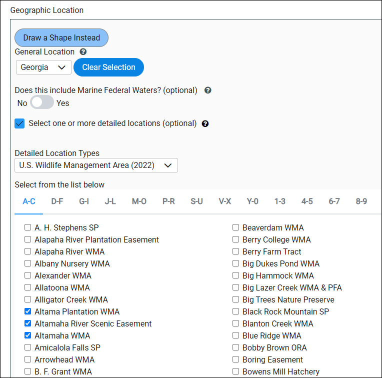
The WMA lists for each State are imported into TRACS periodically from data provided by State agencies that manage WMAs. They are static lists based on the date of system release. TRACS displays the list that applies to the current record based on previous WMA selection. WMA lists are updated no more than annually due to the labor effort required to consolidate, review, and merge data provided by various State agencies.
15. Is there GIS data tied to the WMAs listed in TRACS?GIS data for WMAs is included behind-the-scenes in the WMA dataset; however, it is not currently available in the app for use. WMA shapefiles may be uploaded and associated with individual real property acquisition records.